
I first learned about the Wonderland Trail when I was in junior high, hanging out with my friend K. She talked about how amazingly beautiful the trail was and how she couldn’t wait to hike it. She also told me about Pacific Crest Trail (PCT), a 2,650 mile trail that stretches from the Mexican border to the Canadian border along the West Coast. K said that her dad wanted to hike the PCT when he was younger, but life got in the way. I had never backpacked before, so while contemplating hiking the Wonderland Trail and the PCT seemed like an interesting creative exercise, I did not foresee any pertinent real-life applications.
Well, to make a long story short, Tim and I are going to start the PCT in April 2020! We hadn’t done any backpacking trips longer than 3 days, so we figured it would be a good idea to do a longer trip as a test run.
Enter the Wonderland Trail: a 93 mile trail with 22,000 feet of elevation gain that circumnavigates Mt. Rainier. It’s right in our backyard, and we had heard about the stunning views and wildlife. However, it’s also stunningly popular. This year was our second year in a row applying for backcountry permits and getting denied. So we decided to just show up at a ranger station, since 30% of permits are allocated for same-day reservations. We thought that September would be a good time to do this, since the trail is most popular in July and August, and September fit with our schedules.
Turns out we were right: when we showed up to the ranger station, we got every campsite that we wanted, with the exception of one. This was a little unusual for such a popular trail. Why were we able to do this? Well, the weather forecast was… not great. Heavy rain was forecast for every single day except for the first. We knew the forecast going into our hike, which is something I had to remind myself daily as the rain exponentiated our many miseries on trail. Much more on that later.
A note on mileage: The mileage on the Wonderland Trail is not accurate – no one really knows exactly how long the trail is. The mileages we read on the trail signs conflicted with the official Green Trails map, our Gaia GPS tracking, and sometimes even with other trail signs in the same section. As such, take all mileages with a grain of salt. For this blog post, I used the mileages listed here.
We hiked the trail in the counterclockwise direction (steeper uphills, but the downhills are friendlier to the knees) in 7 days.
Day 1: Longmire to Nickel Creek (13.5 miles)

We started the trail around 11am at Longmire. The sun was out, the birds were chirping, and we were in high spirits. The trail was pretty easy, though it did include some elevation gain. We got some beautiful views of Mt. Rainier at the appropriately named Reflection Lake and ate lunch at Lake Louise, a nearby lake that felt a lot more remote. However, most of the trail was in the forest, so we didn’t see too much besides many, many day hikers. Everyone wanted to know how far we were hiking, and they were impressed when we said we were hiking the whole trail. Somewhere along the way we passed a hiker who asked us where we were camping that night. Turns out her daughter Rachel was was going to be at the same campsite that night. She asked us to say hello if we saw her. We thought it would be unlikely that we would cross paths, but we agreed to keep an eye out for her.
About 11 miles in we arrived at Box Canyon, which had bathrooms with running water (very exciting on the trail) and a place to dump our trash! I told Tim that Box Canyon was my favorite part of the trail so far.
We finally got to Nickel Creek around 6:30pm. The camp was a typical forest camp by a creek, complete with a lot of small flies (but luckily not too many mosquitoes). The day had ended with a long uphill climb so we were pretty tired. We set up camp, added irrigation ditches to our tent setup in case of rain, and enjoyed a vegan chili dinner from Harmony House, supplemented with Minute Rice for more calories. I slept pretty well, though I did wake up in the night with an itchy foot for some reason.
Day 2: Nickel Creek to Summerland (11.3 miles)

We forgot to set up our tarp the night before, and it rained quite a bit during the night. However, due to Tim’s rainwater engineering, our tent and groundsheet were mostly dry. We had a delicious meal of Quaker oatmeal mixed with Carnation instant breakfast and chia seeds to start our day. It tastes way better than it sounds, I promise. I had Cusa powdered tea (which was surprisingly good) and Tim had Starbucks Via instant coffee. Having a warm, caffeinated drink on a chilly day put me in a good mood. By the time we broke camp, the rain had stopped. We were in high spirits.
I felt a hot spot on my foot soon after we started hiking, so we stopped by a stream so I could put on some Trail Toes (an anti-friction cream). Turns out my foot looked like this:


This solved the mystery of the itchy foot in the night. Last night I had noticed some flies landing on my feet (I was wearing sandals as camp shoes), but it wasn’t a concern to me since they weren’t mosquitoes. How wrong I was! Turns out those tiny little flies that were hanging around the campsite were a particular brand of evil called “no see-ums” that delight in human misery and sucking minute quantities of blood. Because of all the friction from hiking, the bites became raised, painful, and extremely itchy. Luckily I had brought a small tube of hydrocortisone cream on a whim, so I applied that, but it could only do so much. The no see-ums also got my lower back, right above my waistband. So my backpack was rubbing against itchy fly bites as I walked. I fervently hoped that the bites wouldn’t blister and pop during the course of our hike. (Happy spoiler: they did not.)
Despite this setback, the rest of the day was pretty okay. We spent a good chunk of the day climbing straight up in a never-ending forest, which was tiring both physically and mentally. It wasn’t too bad though. It rained a little bit but not enough to make us miserable. Finally, we broke out of the forest and into some amazing views of Mt. Rainier. Just kidding – we were hiking in a cloud the whole time, so we couldn’t see anything but fog. We crossed Panhandle Gap, the highest point on the trail, and saw nada.
I am pretty sure that this section of the Wonderland Trail is out-of-this-world beautiful when there are no clouds.
Finally, we made our way to Summerland camp at 5940 feet. Even though it was cloudy, I could tell that the camp was absolutely gorgeous. We had passed Indian Bar camp a few miles earlier, which was similarly beautiful, though at a lower elevation. It was quite cold. We had been lucky enough to be assigned the group campsite, which happened to be a 3-walled shelter! We were quite excited about this due to the rain forecast. It started raining soon after we got to camp, and we were happy to be able to keep our tent dry.

When we arrived at the shelter, there was already someone there. Since the weather had been so terrible, we had anticipated that this might happen. We were more than willing to share our shelter with someone who needed to be out of the rain. Turns out our shelter buddy was none other than Rachel! She had been solo-hiking the Wonderland Trail for 6 days (planning to finish in 9 days), and it had rained every single day. Rachel’s campsite at Nickel Creek did not have as good drainage as ours, so her tent had become a giant muddy puddle. We shook it out and hung up her wet stuff. The shelter soon became a maze of wet tents and clothes hung up in various places. There were quite a few mice and chipmunks running around outside of the shelter, but this didn’t bother us.
Rachel thought the roof of the shelter looked like it might leak, so we set up the tarp under the shelter and “cowboy camped” under the tarp. (Generally cowboy camping is defined as sleeping outside without an overhead shelter, but since my face was exposed directly to the air I’m going to count it). Luckily there were no bugs. This was my first time doing something remotely like cowboy camping, and I enjoyed it. It was much colder than being in a tent, so I had to ask Tim for his extra down blanket and put Hothands inside my sleeping bag for extra warmth. (Side note: We used every piece of “just in case” equipment that we brought during this trip. So that was a good lesson.) When we woke up in the morning, we found that our mouse friends had left us some tiny presents on our socks, but luckily not on our sleeping bags. Still better than being out in the rain!
Day 3: Summerland to Granite Creek (13.9 miles)

The night at the shelter really lifted our spirits. It was so nice to be warm and dry and not worry about getting wet. The other thing that lifted my spirits was the flush toilet. You read that right, a flush toilet. The “flush” was really more like a poop conveyor belt operated by stepping on a lever, but still. It was a backcountry toilet that was enclosed and had toilet paper and hand sanitizer and didn’t stink to high heaven. It was truly miraculous, and I was glad to be able to do my business there.
We had our traditional morning meal of oatmeal, tea, and coffee, packed up our now (mostly) dry stuff, and headed along our merry way. It was raining on and off with a lot of clouds, which was fine with us since the rain wasn’t too heavy. This was our longest day on trail so far and it included a significant uphill section, so I was a little worried about getting to the next campsite on time. Luckily it turned out to be fine. The downhill was super easy and we practically sailed into White River campground, the site of our first food cache.
We had camped at White River the night before starting the trail, so it was nice to be somewhere familiar. Plus, the bathrooms had running water! We ate lunch at the conveniently placed picnic bench right next to the ranger station, spreading the contents of our food cache all over the table. I eventually had to put on my head net due to the bugs, but I was able to eat without difficulty. Since we had dropped off the caches ourselves, we had some perishable foods in our resupply, including oranges, apples, cheese, and Kettle salt and vinegar chips (I’m addicted to them).
After lunch we set off to begin our uphill climb, which wasn’t bad at all. Finally we got to Sunrise, a well-touristed section of the trail. It was so beautiful, even with the limited views we had due to fog. We encountered more day hikers who wanted to know what we were doing and encouraged us. After a bit of wandering through misty alpine meadows, we re-entered the trees and followed some steep downhills to the Granite Creek campground.
Granite Creek is a typical camp in a forest without exciting scenery, which was perfect since all we were planning to do there was sleep. However, when we got there, both campsites were full. We talked to our fellow campers, and they told us there was a sign that said #3 by a trail near the outhouse, so maybe it led to another campsite? We followed the trail for what felt like a mile (but was certainly not actually a mile) and finally found our campsite.
Since it was getting dark, we set up the tent and tarp as quickly as possible before cooking dinner. I had never set up a tarp before, so it was an educational experience. The order of operations was this: determine the area of the campsite least likely to turn into a giant puddle, find appropriate tarp anchors (e.g. a tree, trekking poles, a large straight stick), anchor the tarp to the ground, set up the groundsheet under the tarp, then put up the tent, then the rain fly, then make irrigation ditches and feeble attempts at rainwater drainage solutions. The order of operations were imposed so that the tent would stay dry under the tarp, even if it was raining while we set up.

We must have arrived to camp just in the nick of time, because at the moment we finished setting up the tent it started POURING. I’m talking torrential downpour out of nowhere. Being a magnanimous soul, I volunteered to cook dinner whilst huddled under a small corner of the tarp, trying desperately to cover the rest of myself with my hiking umbrella. Tim retired to the inside of the tent to start unpacking. I made Backpacker’s Pantry Chicken Pad Thai, which I think is the most delicious thing I’ve ever eaten on trail. It felt amazing to eat warm tasty food while the rain poured around us. We took turns eating dinner crouching under the tarp corner, as the tarp was not large to cover both of us. Finally, we went to bed praying that our tent would not be submerged in a puddle when we woke up. I had to pee in the middle of the night, which unpleasant due to the fact that I was being aggressively rained on. It was also worrying to observed the marked change in water levels of the puddles at the campsite. I went back to bed and hoped that everything would be alright.
Day 4: Granite Creek to Ipsut Creek (12.6 miles)

When we woke up, we found that out prayers had been answered! The stakes of the tarp were immersed in several inches of water, but the water stopped about a foot from our tent. We were very lucky. Did I mention it was still raining? I don’t think the rain had stopped at any point during the night. We ate breakfast quickly and tried to get out of there in a hurry. We put on our full rain gear for the first time. I promptly ripped my Frogg Toggs rain pants after popping a squat (those pants are the worst) and had to repair them with Tenacious Tape. I promised myself I would buy real rain pants for next time. I had also had the bright idea of using latex gloves over our regular gloves as rain protection. Within five minutes I had ripped off the thumb, so I spent the rest of the day with a wet thumb. I think this would be the definition of “stupid-light.” Protip: rubber dishwashing gloves would have been a much better, and still ultralight, idea.
Taking down camp in the rain gave us another chance to experiment with the order of operations that would optimize the dryness of our gear. We took off the fly, shook it out, and stuffed it in my pack (all of my other stuff was protected from the rain in a nylofume bag). Then we gathered up the tent and stuffed it in its own plastic bag to keep it dry. Then the groundsheet and poles. Then the tarp. Every step involved copious amounts of shaking gear out and folding fabric/wrapping up tarp ties so they didn’t get tangled.
Starting off in the rain was honestly quite miserable. The day started off with a large downhill section. There were literally small rivers of mud running down the trail, so there was an extra navigation component involved in our walking process. Even the tree cover could not stop the rain. For some reason I still tried to avoid the puddles on trail, even though my feet were already wet. But I knew that they could become even more wet, which would just make everything worse. Luckily, it was not so muddy that our feet were slipping around, and for that I was grateful.
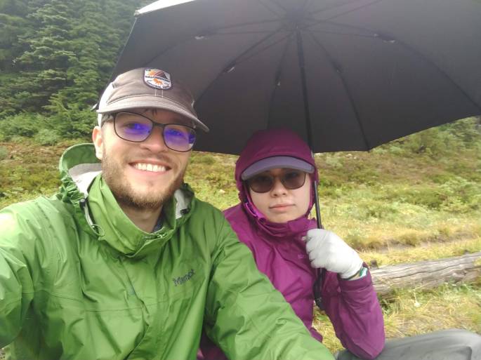
Eventually the downhill turned to uphill, and we climbed to Mystic Lake, on the lookout for a spot to eat lunch that might have some sort of shelter. We didn’t find one, so we decided to eat at the lake since it was quite pretty, the rain had slowed down a bit, and there was a flock of bathing ducks. We sat on Tim’s tiny sit pad and held my umbrella above our heads while eating tortillas. I was feeling a little cranky, but we still managed to keep our spirits high. Until the tuna-mayo incident.

To give some context: one of my favorite things to eat for lunch while backpacking is tuna (or salami, or peanut butter) on a tortilla. It doesn’t sound that appetizing, but it’s great backpacking food. This time I brought along mayo and mustard packets to enhance my tortilla experience. The mustard was great when I made salami and cheese tortilla sandwiches, and the mayo gave the tuna a little extra oomph. On the day of the aforementioned incident, I set up to prepare my tortilla as normal. I carefully placed all of my items on the tortilla and folded it like a burrito. Apparently my burrito folding technique needed some work, because as I picked up my burrito and took a bite of creamy tuna, the tortilla started leaking tuna and mayo – all over my rain pants. My left upper thigh had received a generous dose of disgusting milky colored tuna water. My hand was covered in sticky fish-smelling liquid. And there was nothing I could do about it.
Shortly thereafter or maybe during, it started tipping down (aka raining cats and dogs) again. We scrambled to pack up our stuff and hurried back on trail. At this point, we were booking it through a fragile alpine meadow, and the trail was buried about under 3 inches of water. I felt slightly bad (but not that bad) about walking on the meadow right next to the trail, but I did it anyway. I had not signed up to swim.
Luckily the rest of the trail was downhill. We sailed through the forest and across a slightly sketchy washed out section near a river crossing. The rain let up as we got closer to Ipsut Creek camp, and the trail got wider and wider.
Ipsut Creek used to be a large frontcountry camp back in the day, so it was interesting to walk into a backcountry camp and see a bunch of horse posts and bike racks, two outhouses, picnic tables, bear boxes, and about 50 different campsites. We were so thankful to get to camp. We walked around the camp twice to pick the optimal campsite with respect to tarp-usable trees and rainwater drainage. Eventually we selected the perfect site. Unfortunately, the no see-ums were the worst we had seen on trail, so we walked around in headnets as we set up camp and prepared dinner. I got some new bites, which I was not thrilled about, but not as much as the first night due to my newfound constant bug vigilance. It was barely raining, so at least we got relief from that. Our backpacks were completely soaked but our stuff inside was (mostly) dry. Luckily the camp was at a low elevation, so I wasn’t cold at all. We turned in, happy to be warm and somewhat dry.
Day 5: Ipsut Creek to Golden Lakes (15.7 miles)

Have I talked about the misery of wet socks? At some point, there’s nothing you can do to dry out your stuff. We had all sorts of articles of clothing dangling from the top of the tent, but you can only do so much when everything is soaked. The socks especially did not want to dry. The morning routine for the rest of our trail days went approximately as follows: Wake up in a warm cocoon listening to the pitter patter of rain. Groan as you realize that you need to leave this cocoon at some point and that you really need to pee, so it’s going to have to be soon. Try to find the driest items of clothing you have, and put them on. Rub Trail Toes over every inch of your feet to prevent blisters. Repack your stuff as much as you can. Take your cold, wet socks and drag them over your protesting feet. Open the tent while trying not to let bugs in and squelch into your similarly wet shoes. Get the food bag from the bear hang. Eat a Clif bar that tastes like nothing and that you have no desire to eat, but you need energy so you eat it anyway. Gather and filter water while trying not to freeze. Start the process of taking down camp while trying (and failing) not to get soaking wet.
We had given up on cooking breakfast in the rain, and just resorted to eating bars. It was at this point that I started to lose my appetite, which is a very bad sign. If you know me, you know that I am always hungry and that I am always eating. But it was just so cold and wet and miserable that my body didn’t want to eat. So I forced myself to eat. On this particular morning, I consumed a Pop Tart in addition to my Clif Bar. It tasted like chalk. But I ate it anyway.
We knew we had another big mileage day. The rain let up sometime after we started hiking, which was nice. We started our day climbing up Ipsut Pass, which was beautiful and a much harder climb than I expected. Our moods greatly improved upon being out of the rain. To keep myself in good spirits, I sang a variety of songs and invented some new ones. Tim spotted a mountain goat, which inspired the following ditty:
Oh, oh, oh, I’m a mountain goat!
Look at me in my white furry coat
Oh, oh, oh, in a place so remote
Look at me, I’m a mountain goat!
(There were some other verses, but this was clearly the best one.) We soon reached the food cache at Mowich Lake, which was a welcome diversion. We got rid of a lot of food at this point. We met some day hikers and campers while repacking our food, and saw other backpackers who were still sticking it out despite the rain. We managed to finish lunch right around the time that it started raining again, so we donned our rain gear anew and set off downhill.
Sometime after lunch I started to feel ill. I had the beginnings of a headache and my stomach hurt. After an hour or two, I felt nauseous and had a full-blown headache. “It would be just like me to get sick on this hike,” I thought to myself. I had to take a half hour break at South Mowich River camp to pull myself together. There was no way out but through, so we continued on. I was not looking forward to the next 5 miles of uphill while feeling sub-par.
I started climbing uphill, and I found that taking a break and eating had made me feel a little better. Then it started raining cats and dogs again. For me, this was the lowest point of the hike, aside from the tuna-mayo incident. I was so sick of walking in the rain and so angry from not feeling well. I took out my headphones to give myself the extra encouragement to walk uphill for 5 miles. I listened to Taylor Swift’s Lover album twice on repeat because I didn’t want to stop to change the music. I told myself that once I finished the album for the second time, I would allow myself to ask Tim how far away we were from camp. By the time I asked, we were more than halfway there. I changed my music selection to a mix of Taylor Swift and Natalia Kills (in hindsight, I should have downloaded more music or made a hiking playlist). I meditated on lyrics like “I’m so sick of running/As fast as I can/Wondering if I’d get there quicker/If I was a man” with unusual ferocity. I wondered if Taylor Swift was going to marry this guy she was singing about. And it just kept raining.
Another thing that contributed to our misery was that we thought we were doing less mileage than we actually had to do. Our Green Trails map said that South Mowich Lake was 5.3 miles away from Golden Lakes. Turns out the actual distance was over 6 miles, as we discovered when the trail signs started conflicting with each other. This did nothing to improve our spirits. We finally reached a crest in the hill, and all of a sudden this burst of golden sunlight washed over us and the valley which had unexpectedly appeared before us. I wanted to cry from relief and from the beauty of it all. It felt like Mt. Rainier was saying, “see, it’s okay, you’ll make it through.” Of course it was still raining. And I was feeling sad because I couldn’t find any rainbows. But the fact that we could see a valley meant that we were close to camp!
It felt like a long time before we made it to camp. I was so relieved, but I was also worried about hypothermia. It was cold, raining, and windy, and we were camping at close to 6000 feet of elevation. As we were setting up the tarp, my fingers started to go numb. Tim gave me his gloves, which were wet, but they were still warmer than my gloves. I opened my Hothands and tried to warm up. Finally the tent was set up and I was able to get inside my sleeping bag, which was still mostly dry. But I couldn’t get warm. At some point, I realized that I was not going to die of hypothermia, and that eased my panic, but even with the down blanket and my Hothands going, I did not feel warm. I wanted to read my Kindle, but I didn’t want to leave any more skin exposed than was absolutely necessary, so I just laid in my sleeping bag with the hood tied over my head and thought intensely about how cold I was, while my stomach roiled and the wind whistled. I ate a granola bar, just to get something in my stomach, and I slept with a plastic bag next to my head in case I needed to throw up in the middle of the night.
Day 6: Golden Lakes to Klapatche Park (7.6 miles)

Luckily I did not have to throw up. I woke up in the middle of the night at 1:30am and realized that I felt warm, which was a relief. My stomach felt somewhat better, though it still felt like there was a hard rock rolling around inside there.
We were excited about the upcoming day because it was a low mileage day. Also, it was the penultimate day of our hike, and we were going to go home soon! Surprisingly, despite the endless rain and other miseries we endured during this hike, we had managed not to snap at each other or get angry at each other. Our anger remained reserved for Mt. Rainier.
Well, it poured rain literally the entire time we were hiking. No joke. There were no breaks, no changes in consistency – just heavy, heavy rain for 6 straight hours. I don’t think we took a single photo. We got to camp and set up in the rain, which we were professionals at by this point. We had no desire to attempt cooking dinner, and instead ate some granola bars that tasted like disappointment. We climbed into our sleeping bags at around 5pm and didn’t leave for the rest of the night. I finally got the chance to read a significant chunk of “City of Stairs” by Robert Jackson Bennett, which was an excellent fantasy novel and a great escape from the trail. This made me feel a lot better. We were still in good spirits because we knew that we were going to finish the trail tomorrow. We went to sleep dreaming of hot showers and the burgers we were going to eat at the lodge when we finished.
Day 7: Klapatche Park to Longmire (16.7 miles)


There must have been something in the water, because we heard amorous elk bugling all night. It sounded like they were quite close to us. When we woke up, the bugling had stopped, but we saw quite a few elk tracks.
We were so excited to leave! It felt like everything was wonderful again. It also wasn’t raining when we woke up, which was quite unusual. We hurried to do our camp chores. As I was waiting for the outhouse to become available, all of a sudden the fog lifted and I saw the most breathtaking, up-close, shrouded-in-fog view of Mt. Rainier that I have ever seen. Within 10 seconds it was gone. But that view was really something.
The ranger had told us that it was “all downhill” from Klapatche Park to Longmire. This was patently false upon reading the elevation profile, but it was a much easier day than most. We climbed uphill to Emerald Ridge, which was absolutely stunning and one of my favorite parts of the trail. Eventually it started to rain again (as usual). We passed through Indian Henry’s Hunting Ground and hid from the rain as we ate our lunch on the front steps of the ranger station. I couldn’t bring myself to eat my last tuna packet, but I did my best to eat other stuff to make up for it.
After Indian Henry’s, it started tipping down with an absolute vengeance. I could not believe how hard it was raining. But we were so close to the finish line. We raced towards Longmire, which was significantly easier now that we were going (mostly) downhill. We cheered when we passed Pyramid Creek, the last campsite before Longmire. The rain did not stop or alter its intensity, but that didn’t matter – we knew we would be out soon. The trail started to widen, and all of a sudden I saw a road peeking through the trees. We were close to civilization! Within the next half hour, we had reached Longmire lodge. We had thru-hiked the Wonderland Trail!

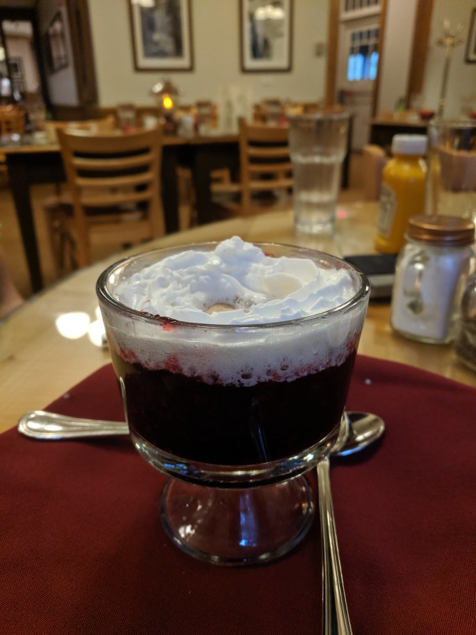
We took a quick celebratory photo at the trailhead and rushed to the car, where we had stashed a change of clothes. I changed clothes, wiped myself off with baby wipes, brushed my teeth, and applied deodorant in the bathroom, which blissfully had hot running water. Another lady entered the restroom while I was washing up, and I felt the need to explain myself as to why I was essentially bathing myself in the public bathroom. She was very impressed with our accomplishment and congratulated us, which made me feel good. Finally, Tim and I went into the Longmire lodge to get the aforementioned burgers. The lodge reminded me of the fancy lodges in Yellowstone. We ordered a salad, two whole burgers with fries, and Longmire’s famous blackberry pie a la mode, and we ate every last bit of it. The blackberry pie was amazing. I also had a phenomenal spiked apple cider, which was just what I needed to warm me up. It was interesting being around other people who clearly had access to showers and clean clothing within the past 24 hours, while we were sitting at our table looking (and probably smelling) like half-drowned rats.
Finally, we finished our meal and headed home. The shower I took was one of the best I’ve taken in my life. It was so exciting to sleep in a warm bed and have access to running water, and I thought a lot about the privileges that I take for granted. I chose to do this hike and to be exposed to the elements. There are many people without homes who don’t choose this, but have to do it anyway.
To be honest, I didn’t enjoy most of the hike. Days 4-7 in particular were quite miserable due to the weather, and I feel like we missed out on a lot of the views. However, a major goal of completing this hike was to see if we could handle bad weather and the misery associated with hiking for a long time in unfavorable conditions, and I think we passed with flying colors. The PCT won’t be all sunshine and butterflies, so having the knowledge that we have conquered difficult times while hiking before will help give us the courage and faith to do so again. That being said, most of the time the weather on the PCT should not be so bad. My sister-in-law I. (who hiked it in 2017) said it rained about a total of 5 days when she was on trail. I’m not sure if we’ll get a similar weather pattern, but I do know that hiking the Wonderland Trail gave me the confidence to deal with bad conditions, and the knowledge that I’m capable of persevering even when I’m miserable. All in all, we are proud of ourselves for finishing the Wonderland Trail, and we are looking forward to hiking the PCT!

One thought on “The Wonderland Trail”